Robert & Barbara's 7700 miles in the 1994 Toyota, June-July 2007
Click on a picture for a larger view or photo collection
 June 10
Barbara and I departed Madison after the Prairie Society Sunday morning program about 2 pm. We camped in Iowa at Winterset city park after missing our turn on I-80 and following I-35 south from Des Moines to Highway 92. We had been heading for a small campground at Casey, Iowa, but opted for the larger campground at Winterset once we discovered our mistake. It proved to be an interesting place to camp.
June 11
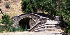
On the morning of June 11 we walked to a covered bridge that had been transplanted to the park and a stone footbridge that we were told had been featured in a movie. Next we drove to Clark Tower, a round stone tower also in the park that overlooks the valley below, and before leaving the park we stopped and walked through a hedge maze. Then we took a little side trip to another covered bridge a few miles away before getting back on the highway west. (The bridge we visited was the Holliwell Bridge. It is designed like the Roseman Bridge featured in the 1992 book The Bridges of Madison County. [map])

 June 12
On June 12 we stopped in Rawlins WY and saw the old Wyoming State Penitentiary and the brightly painted 1903 Ferris Mansion. While we were at the mansion at tour bus came by. At an I-80 wayside further along in Wyoming I took a bunch of photos of prairie dogs near our picnic table and of a long train passing below. It was a hot day, and we stopped for ice cream at Little America WY.

June 13
Continuing on I-80 with just a stop for gas in Salt Lake City we headed due west across the salt flats. There we passed a greyhound-sized brightly painted private bus, perhaps belonging to a touring band, that was being towed off of the salt flats, which had been softened by recent rain. (Wish I had stopped for a photo.)
 Later we stopped at a little cafe in the middle of nowhere to eat. There I photographed the hand lettered sign on the wall by the video game machines which said "ALL UNATTENDED CHILDREN WILL BE GIVEN A CAPPICINO AND A FREE KITTEN". In Reno Barb ran over a plastic bucket on the freeway. It lodged under the Toyota and scrapped all the way to the exit ramp, around two corners into a parking lot. There, with Barb out of the car and looking under it, I was able to back off of the squashed object.
June 14
On June 14 we drove to Donner Park's beach area for a brief look, and then headed down Highway 89 along the western edge of  Lake Tahoe. There we parked near the base of a tall bluff and I took the path to the top while Barb hiked along paths down at the highway level. Farther south, where the highway followed a higher route, we stopped at a spot overlooking Emerald Bay. We continued to Sacramento via U.S. 50. Next stop - Mischa's house in Berkeley.
 June 15
On June 15 Barb and I packed a picnic lunch and drove the narrow winding road (sometimes with no shoulder) to the top of Mt. Diablo. After enjoying the view from the observation deck next to the building at the top we stopped under some large trees part way down for lunch. Then we explored some unusual rock formations.
Mischa's house-mate Karen arrived back home for our 2nd night at Mischa's.
June 16
On Sat. June 16 we took Mischa to the Oakland airport for his trip to a conference of the International Society for Gesture Studies at Northwestern University in Evanston. It would have helped if he had told me to go to the Oakland airport rather than the San Francisco airport, but after a missed exit or two we got him there on time. Then we continued on to Robin's house in San Jose.
 June 17
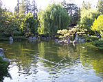
Barb, Robin and I attended the Sunday morning program of the Humanist Community in Palo Alto and had lunch with the group of about 40. In the afternoon we went to the Japanese Tea Garden at Kelley Park, at Story and Senter Roads in San Jose.
June 18
We stayed home and Robin worked at home.
June 19
This morning I took Barb to the San Jose airport for her flight to Portland OR for the UUA annual General Assembly. Then, after getting gas, I visited San Jose's Alum Rock Park. Originating with a governor's land grant in 1778 and dedicated in 1872, it is California's oldest municipal park. (It is easily reached from Robin's Fanwood Court house by taking Berryessa Rd to Capitol Ave, going SE on Capitol to Penitencia Creek Rd, and taking that road to the park.)
 Passing the unmanned entry booth, I drove in perhaps half a mile to the first picnic area, Quail Hollow, and parked. Crossing the footbridge to explore the picnic area I found a trail up the hillside on the far side of the creek. This took me to a narrow paved road that was closed to vehicles. I followed it uphill until it began to descend, and from there I took the South Rim Trail, a dirt footpath up the hillside. This proved to be a good path to follow on a sunny day, because there are plenty of shade trees on the north facing south side of the creek valley. The high barren hill on the far side of the valley looked hot and dry.
 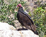 Occasional views of the city of San Jose below showed it covered by a layer of smog. I followed this trail for some time, stopping to photograph a vulture on a large rock overlooking a side valley at the point where the trail started down to the valley. Eyeing me warily as I approached, the vulture finally took flight, gliding downward toward the valley from its high perch. From there I took the trail that zigzagged down to the creek (though there was one smaller side trail branching off that went upward again that I did not follow). At the bottom I found that I was at Aguague Creek, just before it joined Penitencia Creek. A small quantity of water was flowing in it, but soon after it joined the main creek the water disappeared below the rocks and sand at the bottom of the creek bed, to reappear downstream a ways.
Following the Creek Trail downstream I soon came to the Mineral Springs Grotto. As the park was developed between 1891 and 1902, over 20 different springs were identified, including sulfur, magnesia, iron, and naturally carbonated soda springs. Popularity of the springs led to construction of bath houses with tiled tubs into which heated mineral water was piped. Many people thought the mineral waters had medicinal values, a notion that was encouraged by 11 doctors from the area before 1902. There are a number of picturesque stone bridges over the creek.
The picnic areas near the creek were well populated with day campers. On the way from the Visitor Center area to the Quail Hollow I encountered two groups of teenagers on a scavenger hunt. Both groups wanted to take my picture to fulfill one of their hunt requirements, and I agreed.
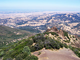
June 20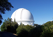 The excursion for this day (after spending most of the morning working on Prairie's Web site) was a trip to Mt. Hamilton with its Lick Observatory. Barbara would not have liked the narrow, winding mountain road, or Clayton Rd, which I took by mistake for a while after missing my turn. The latter was a winding, narrow road up and down hillsides with literally no shoulder much of the way. Beyond its outer edge, the payment went almost straight down. Mt. Hamilton Rd (Highway 130) at least had a few inches of shoulder most of the time, and guard rails in some places. As you near the top after miles of narrow highway you come to an ominous sign that says "Pavement Narrows".
 Well up the mountain I stopped at Joseph Grant County Park and hiked around its lake for a bit. Then I took its Halls Valley Trail for a more shady hike. At other stops along the highway I photographed a picnic area near a smaller lake and distant views of the observatory. I got to the observatory about 6 pm, and took more pictures. Since the main observatory lobby closed at 5 pm I could not get in to see the inside.
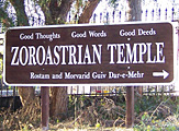 On nearing San Jose on the return trip I took Crothers Rd, hoping to connect with Alum Rock Ave. near Alum Rock Park. On the way I passed a sign for the Zoroastrian Temple, so I took the short steep road up the hill to see that. I took photos, including a view of the city from near the upper end of the road, next to a 2 bedroom house that was for sale for $1,700,000.
June 21
On my last day for excursions in the San Jose area I headed for Alpine Road and Portola Redwoods State Park, planning to be gone all day. Following Robin's advice and the directions he got from Google, I took Berreyessa to I-680, followed it south and west as it curved around San Jose, becoming I-280, and took the El Monte/Moody Rd exit. I followed Moody Rd uphill to Page Mill Rd, then uphill on that. I stopped at Los Trancos Open Space Preserve and did little hiking there before continuing to the ridge top, where Highway 35 goes NW and SE. Just before Highway 35 Page Mill Rd turns into Alpine Rd. Just past Highway 35 I stopped at the Russian Ridge parking lot and headed down the trail underpass to David Daniels Nature Center (open only on weekends), which is on a pond (Alpine Pond) 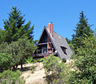 created by an earthen dam. Below the dam I found shaded vehicle-width trails. I followed the first paved trail/road past an employee residence A-frame to (and a little past) a gate at the edge of private property. Then I returned to where the Old Page Mill Trail branched off. It looked so inviting that I decided to spend most of my day's hiking time on it. I followed it as it snaked back and forth downhill to where it ended at a small stream just beyond a large rotting log across the trail. On the far side of the stream's ravine it looked like there was an old trail at least wide enough for riders on horseback. The whole time I was on the nature center side of Alpine Rd I did not see another person, though on my return up hill I did startle a deer, who left a small cloud of dust in the trail as he bounded up the hillside. It stopped at a safe distance and peered down at me before going on.
After eating lunch outside the nature center I drove a short distance down Highway 35 and stopped at the Skyline Ridge Open Space Preserve. There I got a glimpse of Horseshoe Lake, but did not hike down to it. Highway 35 further down-ridge looked pretty boring, so I returned to Alpine Rd, headed for Portola State Park Rd, and followed it to the park. It was after 4:30 when I arrived, and I was not looking for more hiking so late in the day, but I drove around and stopped at some of the picnic and camp sites. (There were no staff at the visitor center, just self registration instructions.) I tried to photograph some of the tall redwoods. 
Returning up Alpine Rd I stopped at a small roadside parking spot and hiked up to the adjacent section of a Russian Ridge trail to photograph the hazy horizon. I also photographed a mountain biker just after he passed me, huffing and puffing, going uphill on the trail.
June 22
I opened the Toyota windows a bit and locked the car, forgetting the keys in the ignition. Robin brought out two clothes hangers. With a square rod I turned the keys and worked them out of the ignition while Robin had them hooked with one of the wires. We retrieved the keys through the 2 cm opening at the top of the window. Once I was able to get underway I drove around San Jose State University, then headed north on I-880. Robin had said it would turn into I-80 near Berkeley and I might not even notice. When I got there signs gave a choice between I-80 west to San Francisco and I-80 east to Sacramento. Took the former and paid the bridge toll (being told my transponder was not responding to the bridge "FastTrac"). I saw the sights around San Francisco (mainly Telegraph Hill and the waterfront), took the bridge back across to the Oakland end (no toll, lower level) and arrived at Mischa's place in Berkeley around 9 pm. I went to bed about 10 pm, leaving note for Karen, who arrived soon thereafter.
June 23
In the morning I loaded the car and then found the driveway blocked with a Prius that had not been there when I pulled in the night before. When I saw the neighbor across the street outside, I asked him if he had seen anyone parking the car there. I pointed out that it had no license plates and the ignition looked like it had been tampered with. He took an immediate interest, and offered to call the police non-emergency number, which he had on his cell phone that he had with him. As he was talking to the police I noticed a tag inside the back window that made reference to "no plates." I could not read the name, but suggested I check with Mischa's landlord David to see if he knew anything about the car. I rang his doorbell at 8 am. David said it was his car. I told him about the helpful neighbor who had just called the police. He met and talked to the neighbor, who called the police back and told them the owner had been found. David immediately left saying he did not want to talk to the police. I gave the book he had lent to Barb to his wife (who had come out front to water her plants) and told her about the police call. She said "oh no" but seem more amused than concerned.
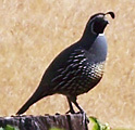 I took the toll bridge across the bay and drove up the coast heading for Pt. Reyes. In San Alemeda I stopped to buy milk and yogurt. Exploring an alternate route to Pt. Reyes I spotted a Bob White on a fence post and stopped to photograph it. Then I turned around and went back to the main road to the lighthouse. I soon reached the Pt. Reyes visitor center and had a little late breakfast in their picnic area.
 The tip of the point was still more than an hour's drive away. As I neared the end of the road to the lighthouse I stopped in a parking area along the coastal beach and had my lunch of yogurt, with grapefruit juice brought from Robin's house. I used a makeshift log bench set up by a previous visitor. Then I drove up to the lighthouse parking lot. One photo from above shows two German speaking visitors at the high point near that parking lot. The many steps down to lighthouse traverse a height equivalent to a 30 story building. The shape of the trees near the parking lot show how strong and persistent the winds are at the point. Passing by several Historic Ranches on the way back to Highway 1, I stopped to photograph several deer near the road to Chimney Rock trailhead.
I found many beaches with public access as I followed Highway 1 north along the Sonoma Coast. Two that I stopped at within Sonoma Coast State Beach were North Salmon Creek and Marshall Gulch. Some of the rugged rocks, sand and waves that I saw are recorded in my photos. Flowers growing on top of a large rock in the water caught my eye at one spot.
I stopped at Stengel Beach which had a sign warning that their gate was locked at sunset. After taking a picture of the sun setting behind the point of land jutting out into the Pacific, I rushed back to the parking lot where my car and one other remained. There I saw a gray fox trotting along the edge of the parking lot, keeping an eye on me by my car.
Looking for a place to stop farther up the coast I found that state camp grounds were all full, including one at Gualala River. (After paying $20 for gas in cash, I had $17 left + coins. One full state campground farther south had said they could find space for me and a tent, though their full sign was up, but they would have charged $25.) I stopped to sleep a little at a big empty Vista Point parking lot just south of the Highway 128 junction. When the cold woke me up about midnight I continued on, stopping again in a redwood forest on a turnout that left more than a car width between my car and the edge of road. I could see the stars in the narrow gap between the tall dark trees over the road. Driving on again about 3:30 am  I stopped at a lighted restroom in Jackson Demonstration Forest, where I took a photo of an old steam engine which I suppose had been used for cutting lumber. Taking the Avenue of the Giants alternate route to see the big redwoods, I took a photo inside what was described as a living chimney tree. Its center had been burned out in 1914. It was about 75' high and 50' in circumference. Farther north I took the much shorter Drury alternate route which went through steeper terrain. Giant redwoods loomed over the road on the right but I took no photos because the digital camera's battery was drained.
The first highway sign I saw with the distance to Portland said 316 miles. I had thought I was half way there and that there were fewer miles left. Now I knew I would not be there in time to meet Barbara at 6 pm to go to dinner at the home of Beth and Chip, friends of Margot Hull. The highway from the coast to I-5 was winding, but better than 1 and 101. When I reached I-5 I was able to travel much faster, but it looked like it would be 7:45 pm before I reached Portland. I spent 15 min. between 5:30 and 5:45 trying to reach Barb from the pay phone at a rest area, without success. I sped on, in case Barb was still waiting for me rather than getting picked up to go to dinner without me. She was indeed still waiting when I pulled into the parking lot at about 7:45 pm, and dinner had been held up waiting for me. After a good dinner and interesting conversation we returned to Oxford Suites and spent the night at the smelly, noisy, expensive hotel.
June 25
Hot breakfast at the hotel was included, but we had to be there before 9 am. Then it was off to Washington State, just across the river. Since it was after noon, we skipped the gardens Barb had thought of visiting uphill from Beth and Chip's house and headed for the Columbia Gorge, which they had told us we "must see".
 and made the climb to the top. Barb was not planning to go all the way up, but when I met her on the way down she was getting close, so both of us went to the top together. (Photo shows Barb sitting on the tip of the rock at the top.) That night we camped at Rainbow Falls State Park, off the Interstate along Highway 6. The falls were more of a cascade, and the pedestrian bridge for viewing them had a big gap in it and was closed for repairs.
June 26
We continued west to U.S. 101 and took it to the coast, stopping to see the world's largest spruce tree at Lake Quinault. It is about 1000 years old and 191 feet tall. Photos show us by its roots. This night we camped at Kalaloch in the coastal section of Olympic National Park.
June 27
We hiked the nature trail at Kalaloch and saw examples of "nurse trees," giant fallen redwoods whiched served as nurseries on which seedlings had grown into new trees. We returned to the Kalaloch beach (where I got to play some more on the big driftwood logs), then continued on to other beaches up the coast. We stopped at the big cedar tree, then at Ruby Beach where I photographed big rocks in the ocean with holes through them.
Well up the highway, after it had turned east, we stopped briefly along the shore of Crescent Lake. Then we continued to the campground exit at Elwha River and set up camp at the Altair campground on the river. We rounded out the day with a side trip up into the mountains to see Hurricane Ridge (taking Race St. south in Port Angeles). On the way down we stopped to photograph the highest mountain in Olympic National Park, Mt. Olympus.
June 28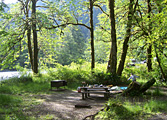 Once again I forgot to take a photo of our camp before the tent was struck. Barb is shown next to where the tent was. Before we left the campgound a deer came to visit the vacant campsite next to ours, and I took her portrait. (Click on the picture at right.) Upon departing camp we drove on up the road the camp was on to Lake Mills above a dam, and on far enough for one photo from the obervation point above the lake. (My digital camera batteries were dead again.) Then we hurried to Port Angeles, getting there by 9:30 am, in plenty of time to get our ticket for the 12:45 ferry to Victoria. [Ferry ticket $55.50.] (Yesterday we had been told all the available reservations, at $10 each, had been taken.)
 and got in on a tour in progress. We were glad to be able to do something indoors since it was raining. Then we headed north. The rush hour traffic was unusually bad. It took us and hour just to get out of the Victoria urban area. I looked up the address for G. Evans in a library phone book and found a map there that showed Maple Bay Rd, Duncan, enabling us to find our way to Penfold Farm, our first night B&B and humanist contact on Vancouver Island. Our hosts were Gary Bauslaugh and his wife Gwyneth Evans. Since it was still raining, Gary directed me to pull the car into his barn, across the drive from the guest cottage, so that unloading would be easier. We were invited over to their house (converted from an old, very solid barn) and had a nice chat.
June 29
Though Gary said they normally bring guests breakfast in the cottage, we were invited over to their house for breakfast. It was our best breakfast of the whole trip, a kind of French toast served in a bowl. We got suggestions from Gary for things to see in the area and climbed the trail up Mt. Tzouhalem and visited the nearby Raptor center. Unfortunately rain prevented the raptor flying demonstration, the main reason people pay the $10 admission fee.
Up island we drove around Chemainus a bit to see the murals and then continued to Nanaimo where we managed to find the little Chase River Estuary Park, where we were disappointed to find no explanatory signs. Next we took a short hike at the much more interesting Pipers Lagoon Park.
We found our way to Sandra Cowan Walker's house about 7 pm. No one was there, but about 7:30 pm I met Sandra coming up the steep drive with her dogs, two friendly greyhounds. We had a late supper with her as planned.
June 30
Sandra had warned us that she was not a morning person, and that we would be on our own mornings. For our morning outing Barb and I hiked up the Notch Hill trail near Sandra's (Nanoose Mt. on maps). In the evening we accompanied Sandra to Rathtrevor Beach Provincial Park near Parksville to walk the dogs along the ocean shore.
July 1
Today is Canada Day. We went in to Parksville to attend some of the events at their Community Park on the coast. We saw some remnants of the parade (which we missed) and heard a number of musical performances, particularly Haley Breedlove and the Tampika Marimba Band. We visited the Parksville ocean beach as a break from the music. The tide was out and I took a series of beach photos showing just how large the beach was. We returned to catch the Tampika Marimba Band. They were said to be the combination of two local bands who have been playing together now for a couple of years. They kept their complex rythms together remarkably well, playing with no written music. A mule deer was lying in the grass at the edge of the yard when we got back to Sandra's. It did not step into the woods downhill until I approached with my camera.
July 2
We got off to a late enough start that Sandra actually got up in time to see us off, about 11:30 am. We headed up the coast highway and stopped at a rest area where oyster fishing was active. Barb saved a colorful oyster shell I found. Later, at another oceanside stop further up the coast near 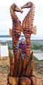 Oyster Bay, we could see snow capped mountains on the mainland, and islands.
We arrived in Campbell River in time to see the results of a log carving contest, and just had enough time to see all the entries (and photograph many) before it started to rain. The viking ship was in a separate driftwood category.
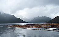
It sprinkled off and on as we headed for Strathcona Provicial Park. We stopped to view and photograph Upper Campbell Lake and Buttle Lake and the mountains across the water with the low clouds obscuring the tops of some.
The rain held off while we set up camp at Ralph River Campground in Strathcona Provincial Park. It sprinkled and rained off and on that night, and there was a little water inside at the sides of tent in the morning, but we stayed dry. 
July 3
It was still a bit drizzly in the morning, so we set off for Gold River, where we enjoyed the lush vegetation of the temperate rain forest along the Peppercorn Park Trail.
 We continued on to the west coast ocean inlet, stopping at water falls along the highway. At the inland end of the inlet we saw logging operations and a large Indian canoe apparently carved from a tree trunk. On the way back up to town we stopped (and turned around) to watch a black bear grazing next to the highway.
Next we took the short hike to Lady Falls. The weather was clearing up.
Some photos of the section of Buttle Lake by the Ralph River Campground. Barb made a fire to fix supper.
July 4
I hiked along the shore and took early morning photos of reflected mountains in the still water. I surprised a greebe family down the shore, a mother and 9 or 10 ducklings. Some climbed on their mother's back as they swam out from the shore, mother croaking for children to follow. Waterfall up the mountainside across the lake.
Karst Creek Trail. Lorquin's Admiral butterfly. Shore at Augerpoint. Lupin Falls Trail. Shepherd Creak Trail. Evening visit to shore near campground.
July 5
Morning photo of reflected mountain along the shore near campground as the sun reaches the far shore.
Heber River Gorge at Gold River.
We drove around the southern end of Buttle Lake as far as we could. Photos of Lower Myra Falls.
July 6 Departing photo of feathers from the shore of Buttle Lake near the Ralph River.
Mt. Washington.
Lady Falls.
Little Qualicum Falls.
Beaufort lakeshore picnic site.
Clayoquot overlook.
Tofino shore at sundown. Hummingbird B&B (ripoff)
Departing photo of feathers from the shore of Buttle Lake near the Ralph River.
Mt. Washington.
Lady Falls.
Little Qualicum Falls.
Beaufort lakeshore picnic site.
Clayoquot overlook.
Tofino shore at sundown. Hummingbird B&B (ripoff)
July 7
Barb visited the Tofino Botanical Gardens and took some photos with my camera 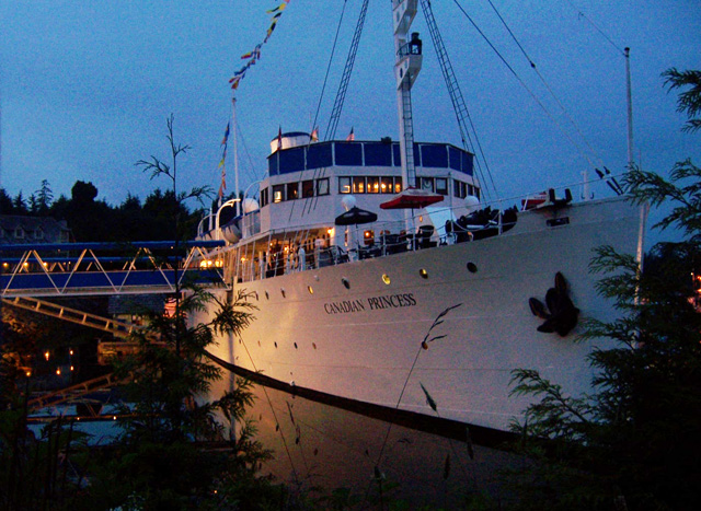 while I visited Tonquin Park on the outskirts of town. I saw many starfish and sea anemones (but have no photos since Barb had my camera).
Lighthouse.
Bald Eagle.
Waterfront, photo from log. (Barb stayed in camp.)
Canadian Princess docked ship near Ucluelet Campground. Buck photographed by eager German tourists.
while I visited Tonquin Park on the outskirts of town. I saw many starfish and sea anemones (but have no photos since Barb had my camera).
Lighthouse.
Bald Eagle.
Waterfront, photo from log. (Barb stayed in camp.)
Canadian Princess docked ship near Ucluelet Campground. Buck photographed by eager German tourists.
July 8
The town of Ucluelet.
Bog walk.
Wickaninnish Interpretive Centre at Long Beach.
July 9
Sooke Region Museum.
Sooke art fair.
French Beach Provincial Park.
Juan De Fuca Provincial Park. Down from the highway to 19 km marker on Juan De Fuca Trail and along to 20 km marker. (I met no one.)
Sombrio Beach.
Port Renfrew.
Shore at Mill Bay.
Botanical Park (tide in, no hike).
July 10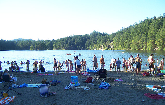 Island View Beach Regional Park (hot and dry).
Saanich Historical Artifacts Society ($7).
Roadside park.
Dunsmuir Lodge of University of Victoria. No sign of John Deer Provincial Park.
Beach access.
Gowlland Tod Provicial Park (wrong end).
Mount Wells Regional Park summit trail.
Swimming at Thetis Lake Park.
Island View Beach Regional Park (hot and dry).
Saanich Historical Artifacts Society ($7).
Roadside park.
Dunsmuir Lodge of University of Victoria. No sign of John Deer Provincial Park.
Beach access.
Gowlland Tod Provicial Park (wrong end).
Mount Wells Regional Park summit trail.
Swimming at Thetis Lake Park.
July 11
We arrived 15 min. early, in time to catch the hourly ferry from Swartz Bay to Tsawwassen (near Vancouver). [Cost for our car and the two of us was $63.50.] The direction signs along the highway left a lot to be desired. We finally made it to Highway 1 and headed toward Banff via it and Highway 5. At Kamloops we waffled about whether to continue on up Highway 5 to Jasper National Park, and then come down Highway 93 to Lake Louise and Banff, but canceled the Jasper idea because Barb was not feeling well. We stopped at the Chase Lions Club RV Park on the edge of Chase BC, across the river from an Adam's Lake Band settlement. There were no tents set up there, but the sign made reference to tent camping. When I got no answer at the host's trailer across the road, we set up our tent in a vacant spot in a numbered site next to a big RV. 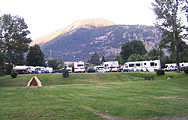 The man in charge showed up just after the tent was set up and said that was the wrong place. It was a "full service" site (had an electrical outlet) and we needed to move our tent down the hill to an unmarked area with no numbered sites where the tents were supposed to go. As the photo shows, we had the official tenting area all to our selves.
July 12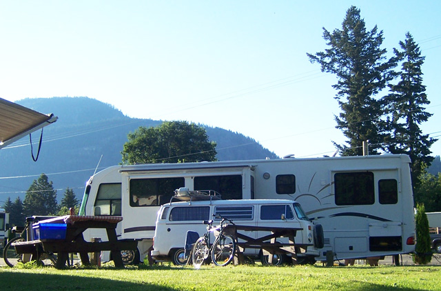 Old and new campers photographed at RV Park, a VW Microbus next to a monster.
We stopped at the location where the last spike was driven for the Canadian Pacific RR at Eagle Pass? We stopped by a bridge over the Columbia River. The photo shows how high the water was.
Banff.
Mount Revelstoke.
Kicking Horse River.
Old and new campers photographed at RV Park, a VW Microbus next to a monster.
We stopped at the location where the last spike was driven for the Canadian Pacific RR at Eagle Pass? We stopped by a bridge over the Columbia River. The photo shows how high the water was.
Banff.
Mount Revelstoke.
Kicking Horse River.
July 13
We took the short hike up to the Johnston Canyon Lower Falls.
Train passing along the Bow River.
Continental Divide.
The highway took us out of Kootenay National Park near Radium Hot Springs, BC, and then back in again as we headed for Redstreak Campground at the southern tip of the park. There we had to buy a park entrance permit as well as paying the camping fee. They had an advisory to boil all water at the camp. Fortunately we had some water with us.
July 14
In the morning we hiked a loop trail at the upper edge of the campground which took us up to a couple of view points overlooking the valley and town below. Then we packed up and headed south on Highway 93, which became U.S. 93 south of the border.
July 15
During the night I woke up and saw how bright the stars were, and told Barbara. (Our heads were by the screen end of the tent, and the outer flaps were tied back because it was a warm night.)  Barbara got up and went to the restroom and observed the stars without her contact in.
In the morning we got up early to make the 2 mile hike up the Avalanche Creek trail to Avalanche Lake. We did not see anyone else along the way, but found an elderly couple had reached the lake ahead of us as well as a fisherman at the far end of the lake. More hikers soon arrived, and on the way back down we met waves of people coming up.
We broke camp and headed on up Going-to-the-Sun Road. We had learned that it had been closed until early July for repairs. Stops along the way included
Logan Pass goats.
Jackson Glacier.
It was too hot to do much outside of the car once we got down to the flatlands of Montana, so we drove until late, stopping for the night at a small motel in Glasgow MT, ľ of the way across the state. Highway 2 was mostly straight with good pavement and a 70 mph speed limit. (It was all torn up in the town of Havre.)
Barbara got up and went to the restroom and observed the stars without her contact in.
In the morning we got up early to make the 2 mile hike up the Avalanche Creek trail to Avalanche Lake. We did not see anyone else along the way, but found an elderly couple had reached the lake ahead of us as well as a fisherman at the far end of the lake. More hikers soon arrived, and on the way back down we met waves of people coming up.
We broke camp and headed on up Going-to-the-Sun Road. We had learned that it had been closed until early July for repairs. Stops along the way included
Logan Pass goats.
Jackson Glacier.
It was too hot to do much outside of the car once we got down to the flatlands of Montana, so we drove until late, stopping for the night at a small motel in Glasgow MT, ľ of the way across the state. Highway 2 was mostly straight with good pavement and a 70 mph speed limit. (It was all torn up in the town of Havre.) 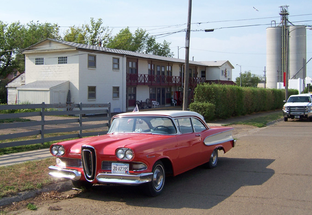
July 16
In the morning we stopped to take a photo of an Edsel in like-new condition outside of the Glasgow MT motel.
July 17
Walked around Powderhorn Lake with Finnegan and looked at Warren's trip photos.
July 18
Walk at Powderhorn Park with Finnegan, Eva, James, Warren & Patty. Eva splashed in mud puddles with her plastic clogs, and made a game of dropping Finnegan's retractable leash, which startled him at first as the retracting handle scrapped over the ground toward him. Adults took over holding the leash.
 July 19
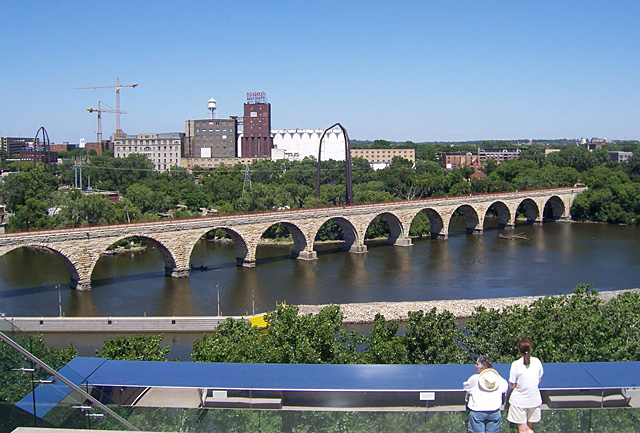
We enjoyed a visit to the stone arch bridge over the Mississippi River (a former railroad bridge turned into a pedestrian bridge) and to the new Guthrie Theater with Warren and Patty. We also stopped at the Edmund Blvd. house and at Daniel and Jamie's new house, and at the DQ near Minnehaha Park.
Barb and I, James and Rita, Joe and Mary Jean joined Warren and Patty at the Sirocco/Flow dance concert at the Ritz Theater in Minneapolis. Maggie the flute (and sax) player also came. It was followed by an opening night reception. Warren's music was featured in several of the Sirocco movements during the first part of the concert. (You can hear this music by going to the Listen Only Department on Warren's Web site at http://warrenparkmusic.com/listenonly.htm.)
July 20
We were treated to a waffle breakfast at Rita's house with the 2 of us, Warren, Patty, Joe, Mary Jean, Eva, Rita and James. We arrived back in Madison about 3:30 pm.
| Toyota trip odometer milestones (places gasoline was purchased on trip) | ||||
| 171 | Departure from Madison on 10 June 2007 | 4757 | Port Alberni BC | |
| 486.5 | Omaha NE | 4905 | Ucluelet BC | |
| 891 | Brule NE | 5086 | Duncan area BC | |
| 1136 | Rawlins WY | 5366 | Victoria BC | |
| 1455 | Salt Lake City UT | 5375 | Saanish BC | |
| 1814 | Winnemucca NV | 5630 | Kamloops BC | |
| 2075 | South Tahoe CA | 5868 | Golden BC | |
| 2408 | San Jose CA | ---- | Radium Hot Springs BC | |
| ---- | Pt. Reyes CA | 6267 | Eureka MT | |
| 2934 | Willits CA | 6466 | Cutback MT | |
| 3208 | Oregon | 6807 | Wolf Point MT | |
| 3524 | Portland OR | 6977 | Stanley ND | |
| 3766 | Aberdeen WA | 7245 | Grand Forks ND | |
| 4038 | Port Angeles WA | 7573 | Minneapolis MN | |
| 4216 | Parksville BC | 7898 | Madison WI | |
| 4524 | Gold River BC | 7727 | total trip miles | |